Chance For Strong To Severe Storms Remains Thursday

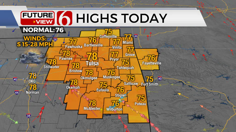
A decaying complex of storms is located nearby Thursday morning and should continue weakening as it moves east. A few of the cells may produce some gusty winds along with pockets of locally heavy rainfall.
What will the weather be like in Oklahoma on Thursday, May 2?
Pressure differences north of the system will cause strong south winds early Thursday morning from 30 to near 60 mph. A short-term wind advisory will be required for this area.

A weak surface front will enter northern OK Thursday morning and slowly sag south by afternoon and evening.
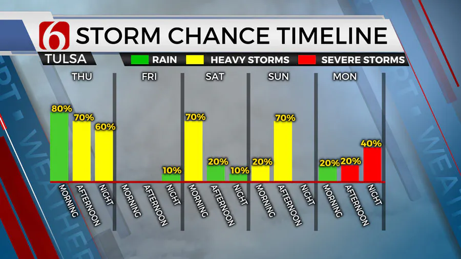
Weak forcing arriving from the west will interact with the boundary aiding in producing scattered storms, including the threat for a few strong to severe thunderstorms.

The exact scenario remains unclear due to the weakening complex this morning regarding some specifics with these probabilities, but the chance of a few strong and severe storms later Thursday afternoon and evening will remain as the front sags southward and stall near far southern Oklahoma.
Are there storm chances this weekend in Oklahoma?
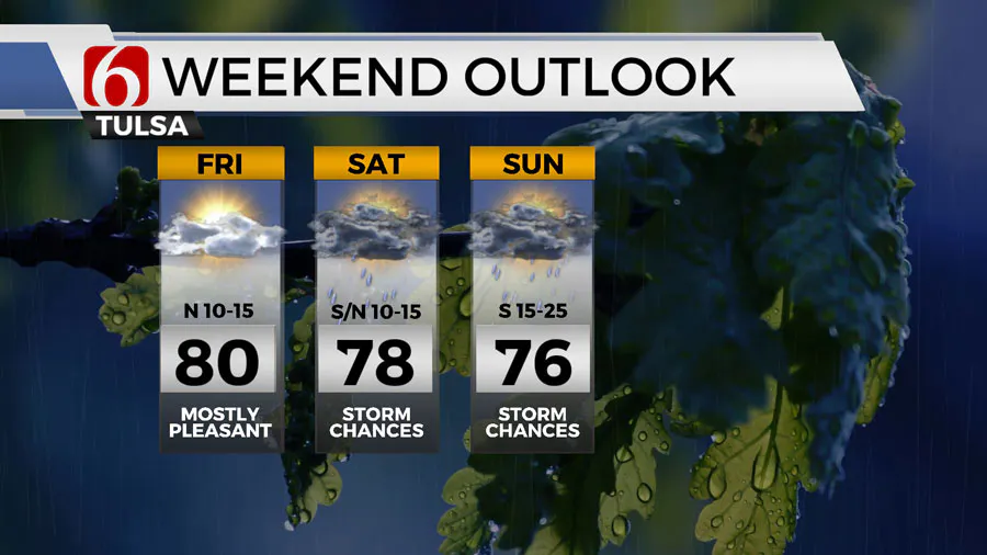
The boundary is expected to retrograde north during the day Friday. A few showers or storms will be possible later Friday evening as moisture returns northward.

Data continues to offer the possibility of a complex of storms developing Friday evening across southeastern Colorado into southwestern Kansas and moving southeast into northern OK Saturday morning through midday.
The exact location and timing of the system may change but we’ll continue with a likely category for the first part of Saturday.

The complex is expected to exit the area midday to afternoon with improving conditions into the evening hours.
What are the severe weather chances next week in Oklahoma?
Sunday into early next week, another powerful upper-level trough emerges across the southwestern states region and begins influencing our weather bringing a lead disturbance across the area Sunday with scattered storms, most of which will be below severe levels.
Sunday night into Monday morning as the trough draws closer to northwestern OK, strong south winds from 20 to 35 mph will bring deeper moisture across the state while a dry line begins to sharpen across far western OK.
Based on the pattern, we'll be watching for severe weather threats Monday and possibly into Tuesday as the powerful upper trough moves across the central plains states and the dry line begins surging eastward.
Some capping issues may be present and may limit some of the activity. Regardless, a weak pacific front is likely to overtake the dry line either late Monday or Tuesday across eastern OK with another chance for storms before activity moves out the state.
Outages Across Oklahoma:
Northeast Oklahoma has various power companies and electric co-operatives, many with overlapping areas of coverage. Below is a link to various outage maps.
Indian Electric Cooperative (IEC) Outage Map
Oklahoma Association of Electric Cooperatives Outage Map - (Note Several Smaller Co-ops Included)
The Alan Crone morning weather podcast link from Spotify:
https://open.spotify.com/episode/5j0ovActG8BZCOTqZQzrfU
The Alan Crone morning weather podcast link from Apple:
https://podcasts.apple.com/us/podcast/weather-out-the-door/id1499556141?i=1000646589555
Follow the News On 6 Meteorologists on Facebook!
