What's the weather like in Oklahoma this weekend? Expect high temps and possibly a pop-up storm

Finally Friday Forecast!
No major changes are expected in the current pattern over the next several days. A strong mid-level ridge of high pressure is centered over northeastern Oklahoma today and will gradually shift eastward through the weekend. This will result in morning lows in the mid to upper 70s and daytime highs in the upper 90s. 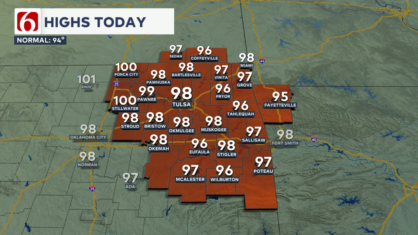 Mostly sunny conditions will prevail, though a few clouds may develop across parts of eastern Oklahoma this afternoon and through the weekend.
The combination of low-level moisture and local evapotranspiration will support heat index values ranging from 105 to near 112 degrees.
The National Weather Service has issued a heat advisory from noon until at least 8:00 p.m. for most of northeastern Oklahoma. 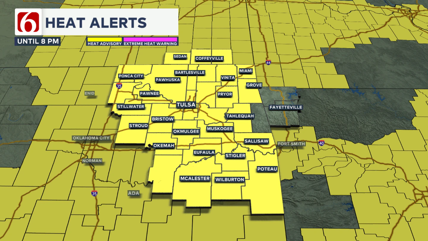 A few counties may briefly reach heat warning criteria this afternoon, with heat index values exceeding 110 degrees. South winds will provide minor relief, ranging from 10 to near 15 mph.
Any Pop-Up Storms This Weekend?
The probability of a pop-up shower or thunderstorm this weekend remains largely confined to extreme eastern Oklahoma and western Arkansas, with most of the area staying dry.
We’ll continue to keep a mention for a pop-up, isolated storm both this afternoon and Saturday afternoon, mostly across southeastern Oklahoma into northwestern Arkansas. 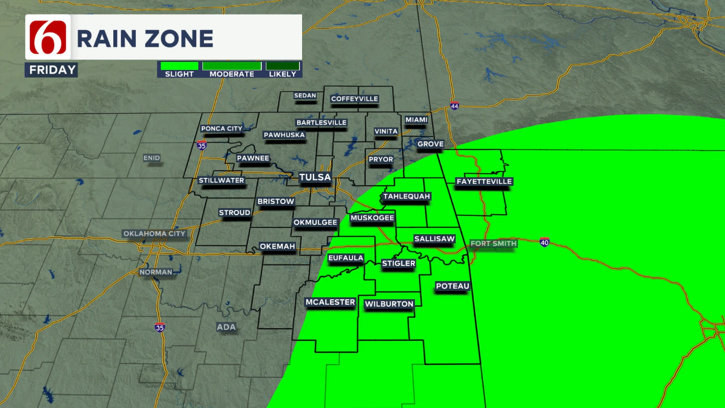 There is a slightly higher probability of a pop-up thunderstorm Sunday afternoon along and east of Highways 69 and 75, though chances for the entire period remain below 10% for any given location.
What About Next Week?
Early next week, the strong ridge of high pressure will retrograde westward and become centered over the Four Corners region as a strong upper-level trough develops across the Great Lakes and into the Yukon region of Canada.
This will support a northerly flow from the Midwest into the Central and Southern Plains by Tuesday, potentially lasting into the latter half of next week.
Monday and Tuesday will still feature highs in the mid to upper 90s, with heat index values ranging from 103 to near 107 degrees. 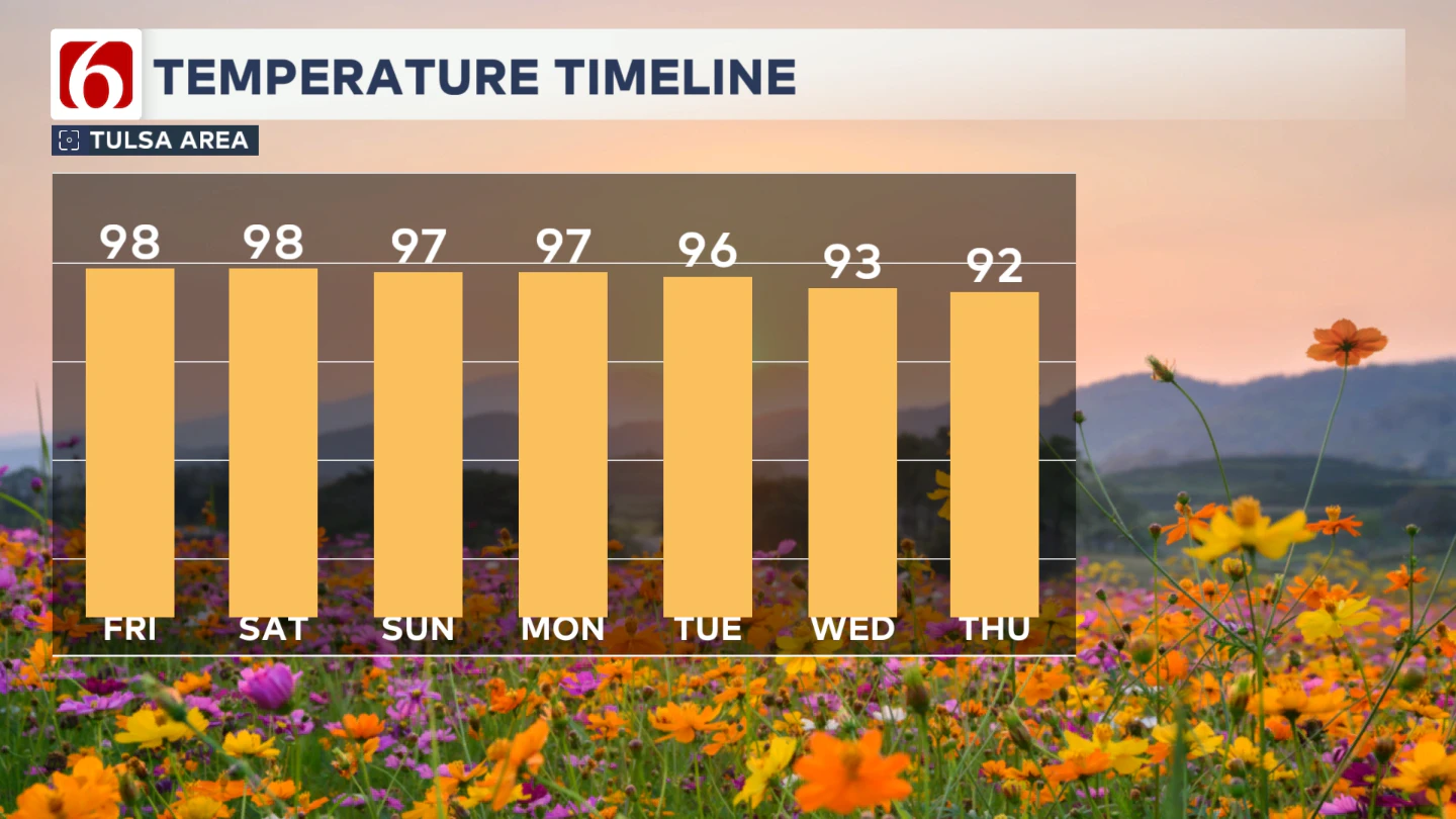 Local heat advisories will likely be needed as the ridge shifts westward and upper-level flow becomes more favorable.
A few showers or storms may approach the area Tuesday night into Wednesday, possibly accompanied by a weak boundary from the Mid-Missouri Valley region into part of northern OK by Wednesday morning and early afternoon.
This pattern change could bring slightly cooler weather than currently forecast, but we’ll keep highs in the lower 90s for Wednesday and Thursday for this forecast update.
Hurricane Erin Update
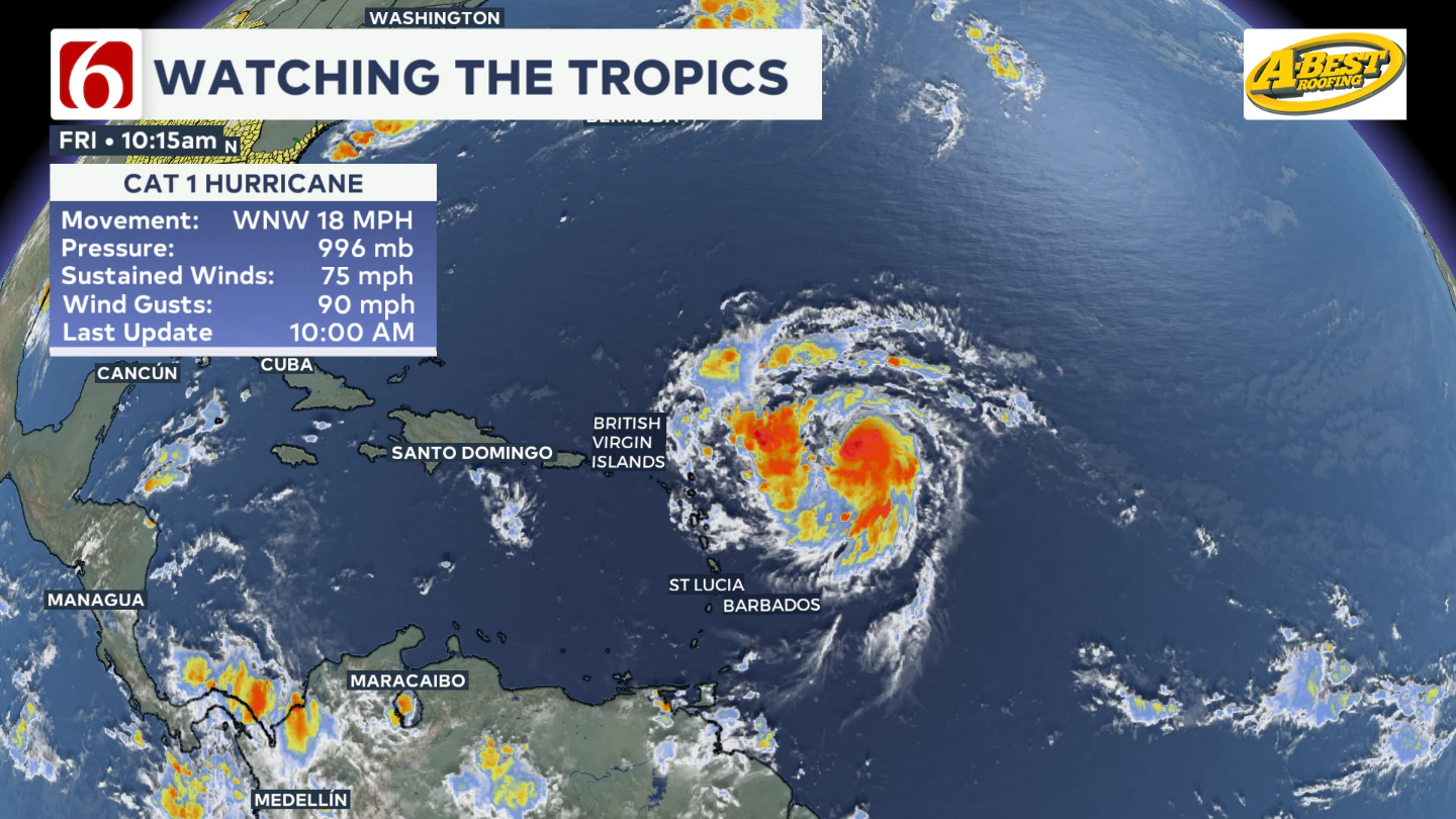
Erin has become the first hurricane of the 2025 season, with maximum sustained winds of 75 mph. It's located about 460 miles east of the northern Leeward Islands, moving west-northwest at 18 mph. It's expected to pass near or north of the Leeward Islands on Saturday.
Tropical Storm Watches are in effect for:
- Anguilla and Barbuda
- St. Martin and St. Barthelemy
- Saba and St. Eustatius
- Sint Maarten
Residents in the northern Leeward Islands, Virgin Islands, and Puerto Rico are being encouraged to monitor Erin’s progress.
Lake Levels
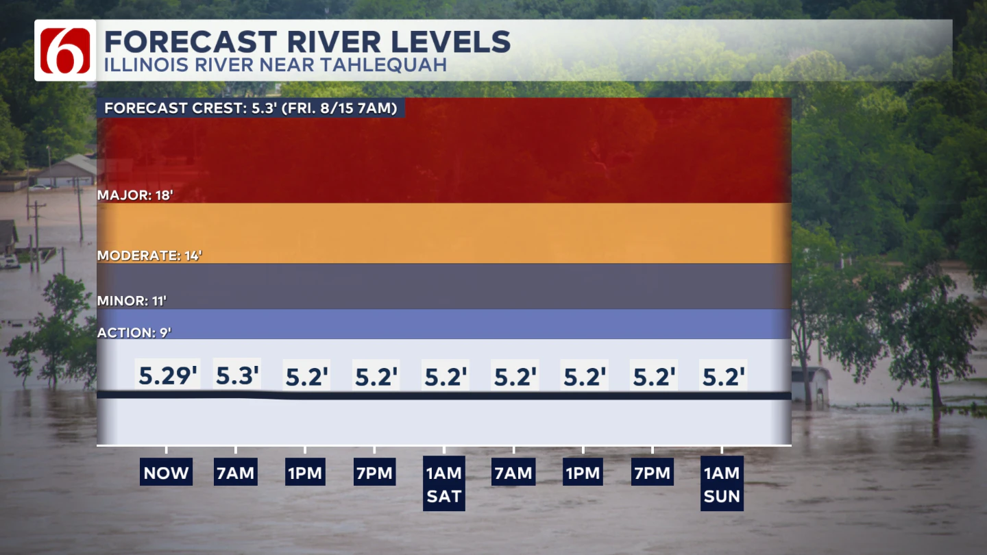
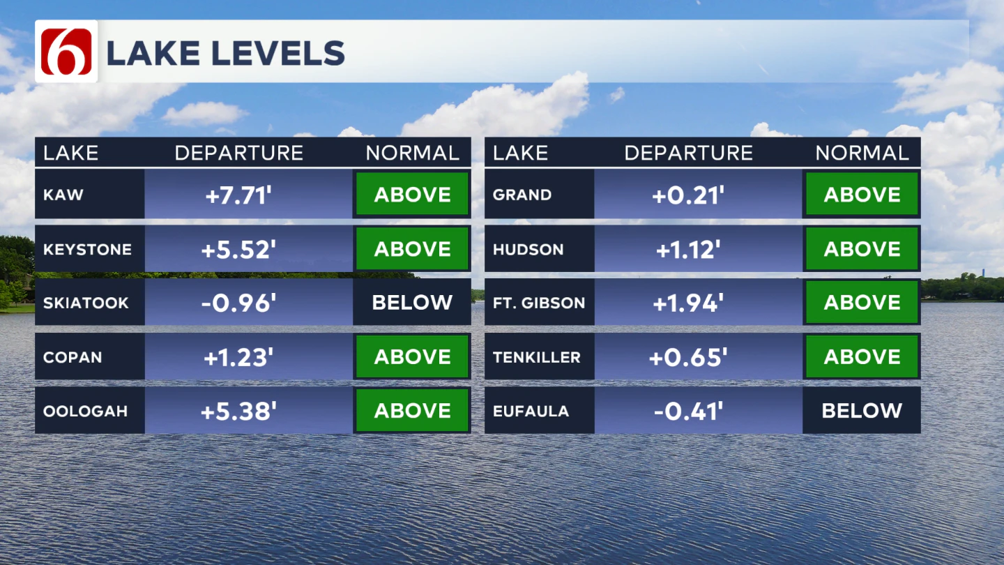
If you're making some lake recreation plans, here's an update on our area lake levels.
The Illinois River At Tahlequah
The Morning Weather Podcast:
The daily morning weather podcast briefing will remain on hold indefinitely due to ongoing internal workflow issues.
We're working to resolve these challenges as soon as possible and appreciate your patience. We apologize for the inconvenience and hope to be back soon. Thank you for your understanding.
Hot weather safety:
🔗 Oklahoma heat safety tips: How to spot and prevent heat illness
🔗 Top summer safety tips every family needs to know
🔗 Swimming pools, splash pads & aquatic centers in Tulsa metro to stay cool
Need-to-know severe Oklahoma weather prep:
🔗Severe weather safety: what you need to know to prepare
🔗Tornado Watch vs. Tornado Warning: what they mean and what to do
🔗Severe weather safety: what to do before, during, and after a storm
🔗Why registering your storm shelter in Oklahoma could save your life
🔗Floodwater kills more Oklahomans than tornadoes in the last decade, here's why
🔗'Turn around, don't drown': Flood safety tips for Oklahomans
🔗5 things to know: How Oklahomans can get federal money to install storm shelters
🔗Breaking down the SoonerSafe Rebate Program: Do I qualify for a storm shelter?
Watch us on YouTube
Follow NewsOn6 on X/Twitter for automated severe weather alert posts: @NewsOn6
Emergency Info: Outages Across Oklahoma:
Northeast Oklahoma has various power companies and electric cooperatives, many of which have overlapping areas of coverage. Below is a link to various outage maps.
- PSO Outage Map
- OG&E Outage Map
- VVEC Outage Map
- Indian Electric Cooperative (IEC) Outage Map
- Oklahoma Association of Electric Cooperatives Outage Map — (Note: Several Smaller Co-ops Included)
