Storm chances in Oklahoma return overnight

An unsettled weather pattern will develop this week and may extend into the approaching weekend, bringing numerous chances for showers and storms across northeastern Oklahoma.
A few strong to severe storms are possible during this period. Additionally, pockets of locally heavy rainfall could increase the risk of localized flooding and rising creek, stream, and lake levels by mid to late week.
A severe thunderstorm watch is in effect for central and western Oklahoma until 1 AM.

Overnight
Late tonight, mostly after midnight, showers and storms will move into the area from western Oklahoma, with the potential for a few strong to severe storms through early Tuesday morning.
By Tuesday morning, scattered showers and storms will be ongoing near and east of the Tulsa metro before they weaken later in the morning. Morning temperatures will be in the lower 70s.
Stormy Tuesday Afternoon and Evening
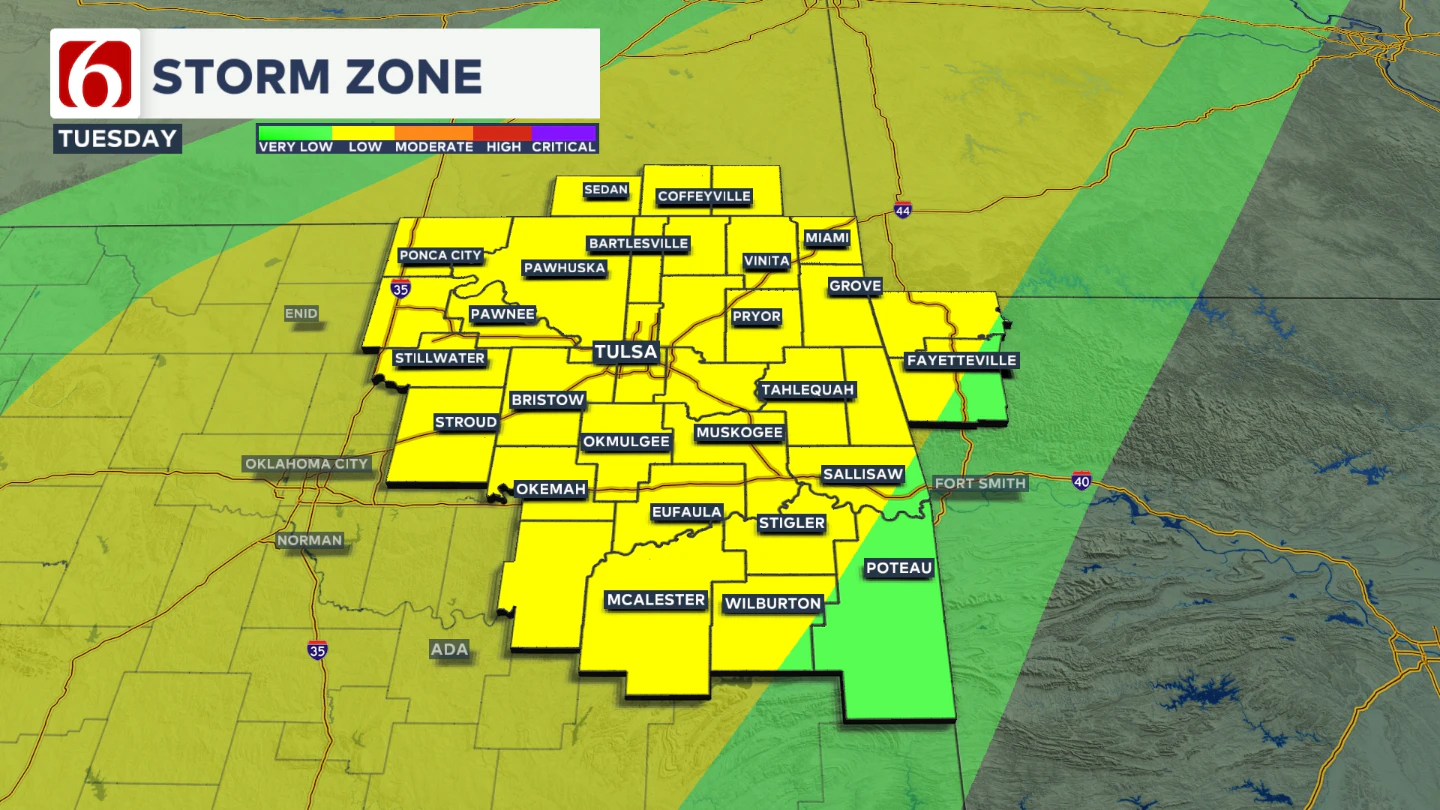
Tuesday afternoon, a slow-moving cold front will approach as an upper-level wave nears the state.

Additional scattered showers and storms will become more likely Tuesday afternoon and evening, with the potential for severe weather. All modes of severe storms will be possible. Daytime highs will reach the mid-80s.
Midweek Update
Late Tuesday night into early Wednesday morning, showers and storms will continue, including the possibility of locally heavy rainfall and a few strong to severe storms. The upper-level support will be moving away from the area early Wednesday morning.
This means the threat of severe storms will be much lower as the upper-level support moves away from the area. The front will slowly move through the area Wednesday, with morning lows in the 60s and daytime highs dropping into the mid-70s with north winds.
Unsettled Pattern
From Thursday through the weekend, additional disturbances will approach northern Oklahoma, increasing the chances for showers and storms.
A boundary is expected to be near northern OK or southern Kansas through this period and will focus the potential for severe weather and heavy rainfall threats.
Thursday morning temperatures will start in the mid-60s, with highs near 80.
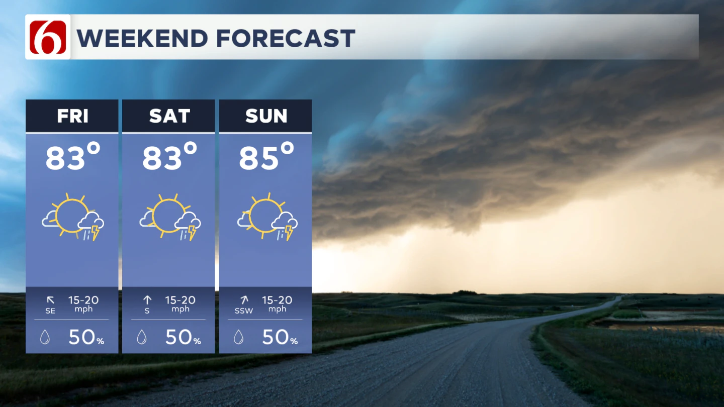
Unsettled Weekend Outlook
Friday through the weekend, morning lows will be in the mid to upper 60s, with daytime highs in the lower to mid-80s.

Numerous opportunities for showers and thunderstorms will continue, including some severe threats and locally heavy rainfall.
The Morning Weather Podcast:
The daily morning weather podcast briefing will remain on hold indefinitely due to ongoing internal workflow issues.
We're working to resolve these challenges as soon as possible and appreciate your patience. We apologize for the inconvenience and hope to be back soon. Thank you for your understanding.
-----
Need-to-know severe Oklahoma weather prep:
🔗Severe weather safety: what you need to know to prepare
🔗Tornado Watch vs. Tornado Warning: what they mean and what to do
🔗Severe weather safety: what to do before, during, and after a storm
🔗Why registering your storm shelter in Oklahoma could save your life
🔗Floodwater kills more Oklahomans than tornadoes in the last decade, here's why
🔗'Turn around, don't drown': Flood safety tips for Oklahomans
🔗5 things to know: How Oklahomans can get federal money to install storm shelters
🔗Breaking down the SoonerSafe Rebate Program: Do I qualify for a storm shelter?
Hot weather safety:
🔗Oklahoma heat safety tips: How to spot and prevent heat illness
Watch us on YouTube!
Follow NewsOn6 on X/Twitter for automated severe weather alert posts >>>>>> @NewsOn6
Emergency Info: Outages Across Oklahoma:
Northeast Oklahoma has various power companies and electric cooperatives, many of which have overlapping areas of coverage. Below is a link to various outage maps.
- PSO Outage Map
- OG&E Outage Map
- VVEC Outage Map
- Indian Electric Cooperative (IEC) Outage Map
- Oklahoma Association of Electric Cooperatives Outage Map — (Note: Several Smaller Co-ops Included)
Follow the News On 6 Meteorologists on Facebook!