LIVE UPDATES: Tornado Warning For Mayes, Wagoner And Cherokee Counties Until 6:45 PM

As Green Country recovers from a very stormy night, we still have another chance of storms and the threat of severe weather to monitor across portions of our viewing area for Sunday.
Leftover rains from our Saturday night system will gradually exit Green Country from west to east during the morning hours. Lingering clouds will keep our temperatures mostly in the 60s for the morning hours before some afternoon sun breaks push us back into the 70s.
Active Watches & Warnings For Sunday, April 28:
- Tornado Warning for Mayes, Wagoner and Cherokee counties until 6:45 p.m.
- Tornado Warning for Haskell, Mcintosh and Pittsburg counties until 6:15 p.m.
- Severe Thunderstorm Warning for Rogers, Tulsa and Wagoner counties until 6:15 p.m.
- Tornado Watch for Hughes County until 11 p.m.
- Tornado Watch for Adair, Cherokee, Delaware, Haskell, Hughes, Latimer, LeFlore, Mcintosh, Mayes, Muskogee, Okmulgee, Ottawa, Pittsburg, Pushmataha, Sequoyah and Wagoner counties until 11 p.m.
- Severe Thunderstorm Warning for Latimer and Pittsburg counties until 5:15 p.m.
Will There Be More Rain On Sunday, April 28 In Oklahoma?
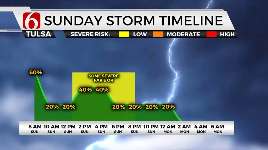
Starting just after lunchtime, more scattered storms look to flare up near and just east of the I-44 corridor. The Tulsa metro could see a few more of these early afternoon storms. By mid to late afternoon, most of the storm activity will be focused east/southeast of Tulsa.
These afternoon storms could once again become severe with damaging winds and large hail the primary threats. The tornado threat will be lower than it was on Saturday, but it won’t be zero and we’ll have to keep an eye out for some rotating storms.

By the mid to late evening hours, the majority of these Sunday storms should be exiting the viewing area. A final isolated storm or two could develop late overnight near the I-44 corridor, but those look to be much weaker.
It looks like we finally get a chance to quiet down and dry out a bit Monday into Tuesday before more storm chances eventually return.
Several tornados have moved through Oklahoma on Saturday. Strong winds, rain, hail, and flooding have caused damage to Norman, Sulphur, Stillwater, and more towns across the state.
Outages Across Oklahoma:
Northeast Oklahoma has various power companies and electric co-operatives, many with overlapping areas of coverage. Below is a link to various outage maps.
Indian Electric Cooperative (IEC) Outage Map
Oklahoma Association of Electric Cooperatives Outage Map - (Note Several Smaller Co-ops Included)

Traffic Impact After Storms:
Following damage resulting from severe weather Saturday and Sunday, several roads across Oklahoma are facing closures.
In McIntosh County, all lanes of US-266 are closed at North 4220 Road east of Checotah due to high water.
In Pittsburg County, north and southbound US-69B are closed between State Highway 113 and McAlester due to high water
West of McAlester, all lanes of east and westbound State Highway 31 are closed between New Baker Road and Haywood Road due to high water.
West of Haileyville, all lanes of east and westbound State Highway 63 are closed between Crawley Road and Hopper Road due to high water.
The Alan Crone morning weather podcast link from Spotify:
https://open.spotify.com/episode/5j0ovActG8BZCOTqZQzrfU
The Alan Crone morning weather podcast link from Apple:
https://podcasts.apple.com/us/podcast/weather-out-the-door/id1499556141?i=1000646589555
Follow the News On 6 Meteorologists on Facebook!
